The People of Limington's On-Line Newspaper
Home www.Limington.org
August 20, 2000 Volume 1 Number 15 Index
Protecting People, Business, and the Environment...Protecting People, Business, and the Environment...
If our Town Officials Won't Do It, Who Will?
Also in this issue:
Bogus Maps Mislead Planning BoardPromised Wildlife Study Turns Out Not to Exist
Planning Board uses excuse to approve road through Resource Conservation Zone
Printing Error by the DEP aids Developer
Deer yard requirements ignored in Paintball Approval
Citizen Petition Submitted to Regulate Cell Towers
Editorial:
High Impact / Low Revenue Projects Coming to LimingtonIn the last issue:
Are Ex Parte Communications Destroying the Credibility of the Planning Board?
Planning Board ignores zoning ordinance
Resident's concerns brushed aside on gravel pit
Paint Ball Industry Struggles to Overcome Rambo Image
Short Takes:
Low Income Housing Application submitted to Planning Board
Four more cell towers?
Local Forum Closed
Jump to the September 23rd edition
If our Town Officials Won't Do It, Who Will?
All stories by Dick Jarrett
The citizens of Limington enact our local laws, but are the laws that protect us being enforced or even followed? Several recent decisions of the Planning Board and Appeals Board lead one to wonder just who is "watching the store" here in Limington. When the laws are ignored, people, their property values, local business, wildlife, and the environment can all be hurt. The short stories that follow document some disturbing incidents where from a lack of attention to detail all the way to outright contempt for our local laws is hurting us all.
Recently there have been two cases where the Resource Conservation District was seriously compromised. And the special section of the zoning ordinance designed to ensure protection of critical wildlife not only was not followed, but was completely ignored during the review process of two separate applications.
The Planning Board is also soliciting input on how the laws should be changed in a whirlwind five hour meeting scheduled for Saturday September 9th. The townspeople should bear in mind that for the most part we currently have pretty good laws and there already are some proposals for change on the table. But just following the laws already enacted by the townspeople would do wonders towards protecting the values that are cherished by the townspeople of Limington.
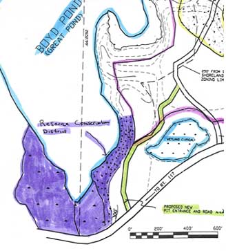
Bogus Maps Submitted by Dearborn Brothers Construction Mislead Planning Board Months ago at the June 8th Planning Board meeting, Dearborn Brothers Construction was told that they needed to show the shoreland zoning boundaries and Resource Conservation Zone on their site plan. Although there were many meetings where this information should have been made public, Dearborn Brothers Construction waited until the August 10th meeting before presenting pretty colored maps showing their interpretations of the zoning boundaries. Waiting until the Planning Board was so tired of hearing this application that the board would pass anything just to get rid of it, Dearborn Brothers Construction apparently tried to pull a fast one on the Board and the public by drawing in boundaries far from the legal lines. They judged the Board's attitude correctly because the Board announced at that meeting that the Board would accept no more public input on the project, input that could have shown where the real lines should have been drawn. Contrary to common sense and actually contrary to the law, the Board allowed only one side the opportunity to present its information.
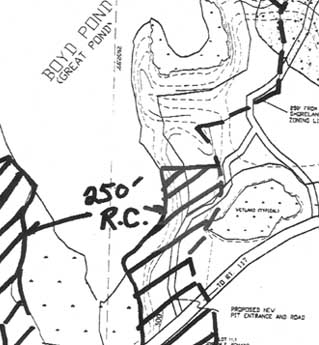
Contradicting their own directives, on August 14th the Board did accept into evidence a letter from the DEP demonstrating that the boundaries supplied by the out of town developer excluded significant sections of the Resource Conservation Zone around Boyd Pond. But the Board still refused any public comment even though this new evidence was submitted. And to add insult to injury, the Board then selectively solicited testimony from various gravel pit operators and allowed a resident of the Millturn Road to speak. If only the turtles who will be crushed beneath the tires of the Dearborn Construction Company trucks could appeal the Board's decision, they would easily win; Maine case law clearly requires that all parties to a decision receive notice of new information and be given an opportunity to respond. But unfortunately while there are plenty of opportunities for gravel pit operators to say their piece, there is no one to speak for the turtles, for the environment, or for the town laws.
Incredibly, even after the DEP demonstrated beyond any doubt that the maps supplied by Dearborn Brothers Construction were outright false, one member of the board complimented the out of town company on its integrity.
Bogus Map submitted by Dearborn Brothers Construction showing incorrect boundaries
Corrected Map presented by DEP
Promised Wildlife Study Turns Out Not to Exist Early in the approval process, residents of the Millturn Road asked that a wildlife study be done to ensure that the proposed pit will not have a negative effect upon the environment and the abundant wildlife in the area. This was not an unreasonable request, especially since it is an actual and specific requirement of the law. The Planning Board even promised to contact a wildlife biologist to evaluate the property, a responsibility which normally should be borne by the applicant. What actually was done? A single letter from Warren Eldridge of Inland Fisheries and Wildlife was submitted stating that the project should not have an effect on nearby wading bird habitat but that the DEP should be contacted for further regulations.
The Limington Free Press visited Mr. Eldridge on the morning of the final approval to see just how much effort was spent on this so called study. It turns out that no study was performed at all for the project! Instead, a computer database was referenced and his letter was based solely on the computer information. Further discussion revealed that the last onsite investigation was done more than thirty years ago and the 1993 computer information, technically labeled "indeterminate", was based on that old study moldering in the files. In fact, the study which was done in the 1960's was recorded on physical punch cards, the old fashioned cards that are sorted by manually inserting rods into stacks of cards which have holes and slots punched around the edges. Only a portion of the data from these cards was then entered into the computer for the 1993 database. An examination the original 1962-1969 study reveals that there are deer, muskrat, and raccoons recorded in the Boyd Pond Resource Conservation Zone in addition to high value nesting, feeding, and migration for waterfowl. Unfortunately, only the wading bird habitat was entered into the computer database so that is all that was reported to the Board. And what about the turtles that are so plentiful in the area? Could there be endangered species like in nearby Waterboro? Well, turtles were not a category back in the 1960's so that they were never even considered.
Even though no study was done, could this single letter be considered adequate for the Board to make a decision? Not if you read the zoning ordinance. In fact, one citizen asked specifically if the board was going to consider the critical areas overlay section (section 6.6) of the zoning ordinance. The citizen's concerns were abruptly put off with the reasoning that the Board had just decided not to allow a road through the Resource Conservation Zone. Moments later when the Board changed its mind again and decided to allow such a road, the requirement was conveniently forgotten. That section states "In determining whether adverse impact will occur, the Planning Board shall require from the applicant written documentation ... regarding the probable effects of the proposed ... use on significant habitat and species. The requirements of this section shall be in addition to, and not instead of, the requirements of Section 9.7 of this Ordinance, governing Conditional Use Permits." The Eldridge letter was submitted to satisfy section 9.7. Where was this additional information required by law and promised by the Board?
The Board refused even to listen to this new evidence about the inadequacy of the single letter that was submitted as the final word on the effects on wildlife in the area. So in the end, the real wildlife concerns were ignored by the Board.
Planning Board uses excuse to approve road through Resource Conservation Zone Dearborn Brothers Gravel Pit approved with minimal conditions.
The maps supplied by Dearborn Brothers Construction conveniently and falsely show their proposed road outside of the Resource Conservation Zone around Boyd Pond (please see the story above). After the Board received the letter from the DEP documenting that the road did indeed go through the zone, it appeared for a few minutes that the Board would disallow the road and require the applicant to use the existing pit road or more appropriately, a road directly to Route 117. But then the Board had second thoughts. The advantages to the contractor would be many if they could destroy this wildlife area. Firstly, Dearborn Brothers Construction would be able to mine the gravel around the proposed road, gravel that would normally be off-limits because it is located in a Resource Conservation Zone with recorded high wildlife value. Secondly, the 150 foot street line exclusion zone can be eliminated wherever new entrances and exits are created, allowing even more yards of gravel to be mined. Thirdly, the out of town contractor would have to fix up fewer feet of the town's Millturn Road if the conservation zone was despoiled.
But these advantages to the operator could not be used by the Board to justify a road through the protected zone. Stating that "People are more important than animals," the board reasoned that the trucks would go by three fewer houses if the road went through the zone. With no public input allowed, no one could correct their miscounting in that the trucks actually would go by only a single additional house. The hypocrisy was thick when the board stated that the old entrance was too close at 500 feet to one of the houses while at the same time the Board refused to place any restrictions at all on excavations which will be allowed as close as 100 feet to the same property. The dust and noise created by these nearby excavations would far exceed the effects of a truck on a 500 foot distant paved road. If people are more important than animals, what was left unsaid is that profits are more important than people.
The Board has often said that if the developer crosses his t's and dots his i's, then the Board must approve the application. But this is not entirely true. As long as the Board makes written findings based on evidence in the record, it can deny the application. While the Board cannot explicitly require the applicant to find an entrance on Route 117, it can indirectly make such a requirement by denying the application, based on the zoning ordinance requirement that this commercial operation must avoid the use of residential streets. By following the zoning ordinance, the local residents could easily have been protected. But that would have been pretty hard to do for a Board that finds that "gravel is beautiful".
Printing Error by the DEP aids Developer The case of the missing dots.
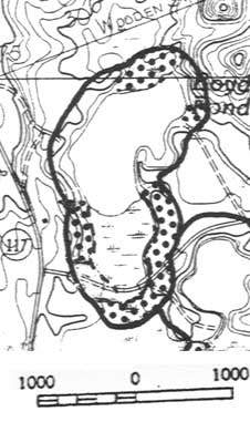
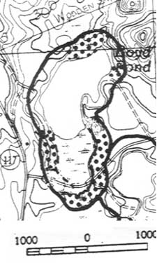
Back in 1994, the Maine Department of Environmental Protection (DEP) imposed State minimum shoreland zoning on the Town of Limington and a zoning map was drawn up. In 1999, reacting to pressure from White Brothers Inc., the DEP changed the zoning map to eliminate from the state minimum requirements one Resource Conservation Zone in a wetland in their gravel pit in South Limington. No other changes to the map were to be made. The Resource Conservation Zone is signified by a series of dots in the shoreland areas. Somehow, out of the tens of thousands of dots on the map, a handful of dots fell off when the new map was printed. These five dots represent an area of approximately 250 feet by 400 feet in the Dearborn Brothers Pit.
Fortunately for the citizens of Limington, the town's zoning ordinance specifically includes the original area in the text of the ordinance. Unfortunately for the citizens of Limington, the Planning Board tends to ignore the ordinance if the DEP regulations are more lax. Although the local ordinance specifically states and the DEP has stressed to the Board that if two regulations contradict each other, the Board must follow the most stringent, the Board invariably chooses to follow (quite illegally) the least stringent "because we need to follow state shoreland rules". For example, the DEP pointed out that the contractor only owns to the high water mark of Boyd Pond. While the DEP would allow the operator to excavate up to 100 feet from the pond in certain areas, the ordinance enacted by the voters of Limington requires gravel excavations to keep back 150 feet from a property boundary, including such shorelines. The Board has ignored the voter enacted requirement and is allowing the operator to excavate within 100 feet of this property line.
1994 DEP Shoreland Zoning Map and area specified by text of Limington Zoning Ordinance
1999 DEP Shoreland Zoning Map with Missing Dots on east side of pondWhich boundary of the Resource Conservation Zone will Dearborn Brothers Construction use? The maps supplied by the contractor clearly show the most lax boundaries. The boundaries as required by the zoning ordinance and as pointed out by the citizens were conveniently and illegally ignored by the Board.
What will the DEP do about its "Map Reproduction Error"? Probably nothing, but watch out - They may use this error as an excuse to re-evaluate and remove even more protected land from the state shoreland requirements. When the DEP does desire to make a change, the citizens of the Town are not informed. Only a few selected town officials are notified and the public and even the full Planning Board will never know that a change is in the works.
Deer yard requirements ignored in Rogue Paintball Operation On August 10th, the Planning Board approved the Rogue Paintball application with conditions. The Planning Board should be commended for protecting nearby properties such as the abutting Francis Small Heritage Trust nature preserve. The Board also established setbacks to protect Whaleback Brook, a local stream recognized as one of two of the best salmon breeding brooks in Maine. But the Board seemed to overlook the effect that the application will have on the mapped deer yard which extends into part of the property to be developed. Like with the Dearborn Brothers Construction company's gravel pit, the town's zoning ordinance (section 6.6) requires that the applicant submit written documentation that the proposed use will not have an adverse effect upon this critical wildlife area. This documentation is mandated above and beyond the standard conditional use requirements that all applications must supply. But like with the turtles on the Millturn Road, it is unlikely that Bambi will file an appeal to the Planning Board decision.
Appeals Board Strikes Again Chastised for acting outside their authority on one road slope application, the Appeals Board finds another way to circumvent the Town's road slope provisions on a second application.
On August 15th, the Limington Board of Appeals struck a further blow to the safety of our local volunteers who serve the townspeople on the fire and rescue departments. At issue was a 250 foot long driveway on a steep slope located off of the Doles Ridge Road in the Rural Zone. This is on a lot in the same subdivision that has plagued the town with legal problems for the past six years after the Planning Board illegally declared that the 1983 zoning ordinance was unenforceable and approved a two acre lot subdivision in the minimum three acre lot zone.
Code Enforcement Officer (CEO) Freeman Abbott had ruled that since the driveway was longer than the 100 feet specified in the zoning ordinance, the road must adhere to the maximum road slope requirement of ten percent in the Rural Zone. The purpose of this requirement is to protect fire and rescue personnel who may need to travel on the road. The Town Lawyer had already opined that the Board of Appeals had no authority to relax the slope requirement as had been done illegally in the past (see stories in the July 19th and August 3rd issues of the Limington Free Press). However, in this particular case, due to the layout of the steeply sloped lot, the house is still only 75 feet from the road, even though to get to the house a vehicle must travel 250 feet on the steep driveway. The Appeals Board apparently used this proximity to the road and their interpretation of the zoning ordinance wording as an excuse to overturn the CEO's decision. Both the Town Lawyer and the CEO had submitted written comments to the board urging them not overturn the road slope requirement.
The score now stands:
Steeply sloped roads: 2
Safety for town volunteers: 0
Citizen Petition Submitted to Regulate Cell Towers in Limington Reacting to the threat of cell towers popping up all over town, a group of citizens has submitted a petition to amend the Limington Zoning Ordinance to enact some regulations on these structures. To limit the visual and wildlife impact of the towers, the proposal limits the tower height and prohibits continuous lighting. The registrar of voters has validated 100 signatures of Limington residents, which is more than the required minimum to place the proposal on the ballot. The Limington Planning Board has scheduled a public hearing on the amendment for Saturday September 9th starting at 9AM. The full text of the proposed amendment is available both at town hall and on this website.
In a related development, local pilots have started complaining about the one cell tower in town already constructed. Apparently, the tower is located on an almost direct line with the Limington Harmon Airport runway. While the tower is probably far enough away to be legal under FAA guidelines, pilots worry that one of the many inexperienced student pilots who use the airport for training might get confused and crash into the tower.
Planes around the airport are allowed to fly 500 feet above sea level. Since the ground elevation at the airport is 300 above sea level, this means planes routinely fly 200 feet above the ground in the area. With a new 190 foot tower proposed on River Road which is close to the other end of the runway, this leaves only a 10 foot margin for error. To alleviate the problem, the citizen amendment proposes to limit the tower height to ten feet above the tree line which is modeled after the standard recommended for towns on Cape Cod.
Editorial:High Impact / Low Revenue Projects Coming to Limington Is this a result of Limington's High Business Property Taxes?
Nine years ago, the Limington Comprehensive Plan called for the town to establish an economic development committee to study ways to bring desirable business into town as a way of increasing the tax base without increasing local taxes. The Town of Limington is now plagued with new proposals that have a high negative impact on local taxes or on the lives of the residents but bring in few tax dollars. In contrast, Limington is having trouble attracting business such as new machine shops and light manufacturing, companies which bring in both jobs and economic benefits. One reason may be the aggressive optional tax collecting policies instituted by the selectmen. Manufacturing companies usually invest a lot of money in machinery. These high capital expenses are multiplied when the owners must pay a percentage of the machinery value year after year to the town in the form of business personal property taxes. Most small towns want to attract businesses and as a result only collect a small portion of these funds or give a tax break like Hollis did for the Poland Spring bottling plant. On the other hand, cities like Portland usually charge the full tax burden, a policy that Limington has copied. As a result, towns like Hollis get the high revenue bottling plant while Limington gets the low-income housing project that will supply the minimum wage laborers to the Hollis plant.
What are some of these recent high-impact, low-revenue projects that are coming to Limington? Read the list below and see if you think this is the type of development that will be the best in the long term interest of the Town and the taxpayers.
Low-Income Housing:
This project will bring twenty new low-income families to Limington, placing a burden on our schools, police, rescue, and public assistance programs. The projected revenue from property taxes is minimal and will be far less than the actual costs to the taxpayers. The result: the existing Limington taxpayers will have to make up the difference.Gravel Pits:
This industry is probably one of the most disruptive commercial activities that can occur in a residential area. The noise and dust from the excavations permeate the air of the surrounding properties. Heavily laden trucks pound down our local roads, roads that must be repaired at taxpayer expense. The current $50 per year CEO pit renewal fee covers minimal code enforcement. Many of the gravel contractors are from out of town so that Limington does not even receive the excise taxes on their trucks. And the wildlife habitat that the people of Limington cherish is bulldozed under a cloud of choking dust. The residents and the wildlife receive all of the negative impacts, the local taxpayers bear the expense of the roads and enforcement, and the gravel operators end up returning very little to the town.Cell Towers:
Here is a new business that may return some tax revenue and service to the local community. However, if done carelessly, it will have a highly negative impact on existing business such as our local airport. Limington's rural character, which is the number one priority specified by the residents in the Comprehensive Plan, could be forever changed by poorly thought out development in this field. Visual and wildlife impacts will be greatest if tall lighted towers start popping up all over town.Paintball Operations:
Paintball operations do not require permanent structures so that as a result they will return very little tax revenue. They may bring in a small amount of economic benefit if refreshments are purchased locally. They can have a high negative impact on neighboring properties, roads, law enforcement, and wildlife if not monitored closely. In one case, a four hundred acre parcel currently in the tree-growth program will be used for this commercial activity. The tree growth program allows landowners a tax break for low intensive activities such as tree farming and open space uses, uses that require very little town services. The selectmen can determine if the tax break, subsidized by the remaining taxpayers, will continue once this commercial activity begins.Dick Jarrett
If you have comments on the stories in the Limington Free Press or other issues of interest to the people of Limington, please feel free to send them to Admin@Limington.org for possible publication in this paper. Please include your name, phone number, and email address for verification.
Would you like to be notified by email whenever a new story appears in the
If so, email your request to Admin@Limington.org All addresses are kept confidential.
View the Index of the Limington Free Press
Please note that
www.Limington.org
is not the official website of the Government of the Town of Limington.